Sunday, March 31, 2019

Double Stack Ruins


Here is my recording of the Double Stack Ruins on Butler Wash near Bluff, UT.  We didn’t follow the hike from the AllTrails trailhead listed but one over due to Butler Wash crossing problems.

I press record on my IPhone on the AllTrails App to track our route.  This is very important when washes and rock surfaces start to look alike.  It allows you to know exactly your trek and how to get back to your vehicle.  This is so important when it comes to crossing Butler Wash.  It rained a lot and washes over others tracks and leaves mud.  It’s hard enough to walk through fresh mud, so you want to walk the same way back as the surface where you walked has dried a bit.


Above is a good example of one of the cuts in Comb Ridge.  Kind of the cut between the teeth.  A canyon that ends with a wall in some cases and sometimes rises up to overlook Comb Wash to the west.

With so many of these cuts in the ridge there are numerous marked and unmarked ruins and petroglyphs.  This one is labeled.  This time of year there are many people out exploring like we did.


There were a couple of these shelters on trail to cave/ruins.  We don’t know about them but figured I’d take a picture.  Although they may not be 800 AD we did find sticks and corn cobs that did date back that far.


Comb Ridge has many carve-outs or caves where native activity may be still present or may be non existent.  A look into most iscrequired to figure out the mystery.  It’s the fun of exploring.  Joanne is good at picking out petroglyphs, Susan is good with finding pottery chards.  I find the way up as most require climbing.  I go up and check things out and let Joanne and Susan know what there is to see.


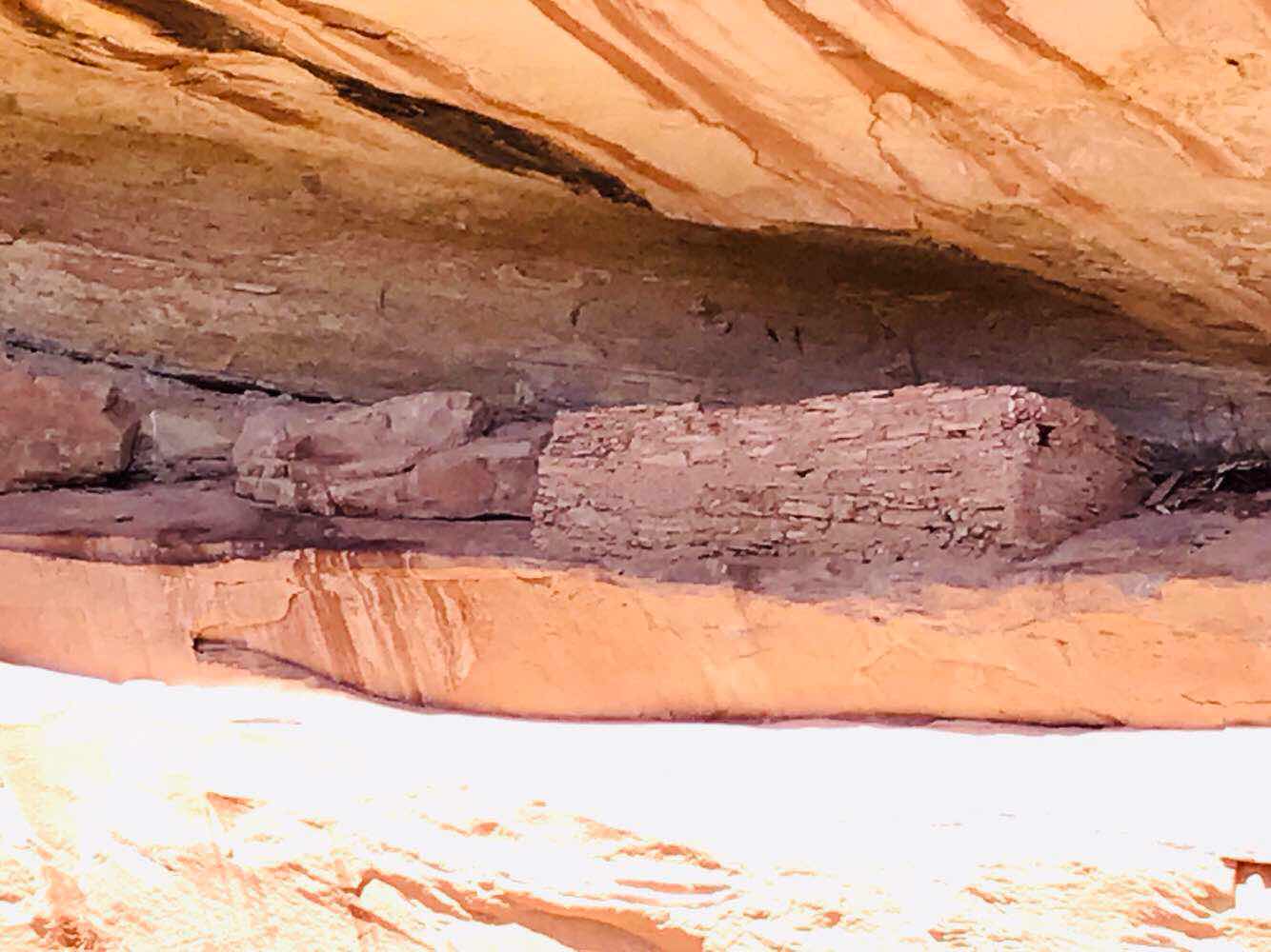
Some ruins you can get up close to see and sometimes it’s too dangerous to climb to them.


When you do get close and you have seen a few you can see that the natives shared buildings styles.


They were good st using natural features in the rock to assist with building.


In this area it is popular to see hand paintings.  


We often spend a half hour per ruin to look around and Joanne looks for the detailed markings on the rock walls.


Here is a look back out the comb 

You have to like exercise through hiking and climbing.  There are so many places and things to see and do.

Brent

macaloney@hotmail.com

Saturday, March 30, 2019

Investigating Comb Ridge


The first morning on Butler Wash the temperatures were down in the 20’s as a result of the storm followed by the cold front.  Here my Tacoma windshield is all iced over.


Here is my camper with Comb Ridge in the background.  Butler Wash is in between my camper and Comb Ridge.  Here the Butler Wash is well carved into the stone.


We (Joanne, Susan and I) headed out in Joanne’s Jeep to check out the road. I also need to include Cafe, Joanne’s service dog that goes where we all go.  It was in very rough condition.  Dried in the foreground and very muddy and slippery in the wet areas.  In a number of these wet spots it was difficulties pass even in 4x4 low, but Joanne did it.  We stuck to the lower Butler Wash to check out the area.  We have been here before but only focused on the “low hanging fruit” (easy to access hikes). 

The road conditions are the worse we have seen in the past few years.


Above is Comb Ridge (white Rock) with crosses lines that gives theclook of a Comb. On the right side where there are pin drops is Butler Wash.  

On the left side is Comb Wash.  Comb Wash is larger and flows more water than Butler Wash.  On Comb Wash Road you have to cross Comb Wash and if the road is not groomed well there is no driving it until it has been.  As for Butler Wash Road it does not cross Butler Wash so the road is generally more accessible, if not muddy.  It usually dries on the lower wash (near US163) area before the upper wash (near UT95)


Driving north on Butler Wash on the left are the colorful Sandstone.


On the left side is the Butler Wash and Comb Ridge in the lighter sandstone.


Every hike into the comb to see ruins and petroglyphs requires crossing Butler Wash.  In many places it is very slippery mud.  All three of us fell at one point by loosing our footing in the slippery mud.

Nature’s markings are fun to see in the riverbed. A hiking stick turns into a necessity crossing washes. 


Hikes take you to the Comb through washes, or up and down into washes.  Some dry to start that turn wet.  There is no one hiking condition this time of year.


In Butler Wash there are a number of large trees that benefit from the wet conditions in the wash.


Even this hike to the west looking back to Comb Ridge is a great hike for views.


My AllTrails App for Butler Wash shows at least 10 hikes to view ruins, petroglyphs, caves, and vistas.  

As mentioned before that after you see all these,  exploring can uncover many more excellent things to see.  If you finish Butler wash then you may be ready for Comb Wash, if the road is ready.

Brent

macaloney@hotmail.com

Tuesday, March 26, 2019

Goosenecks State Park, Mexican Hat, Utah


The morning after camping in the Valley Of The Gods, and after driving the Moki Dugway, we stopped at the Goosenecks State Park.

I had not been before I was interested in going.


The feature here is walking along the rim of the Canyon that is created by the San Juan River that flows eventually into the Colorado River.

There are rafting excursions that will take you through the San Juan River here.


There are multiple horseshoe bends creating some great natural features.

The only thing g I wish isvthat the etched rock on the walls of the canyon were more colorful like imother places in Utah

If you are in the general area it is worth the Utah State spark fee to sped a bit of time to see the San Juan River and how it carved outhouse is serpentine path through the rock.

Tonight it’s on to Butler Wash up the road in Bluff, UT for hiking to ruins and petroglyphs.

Brent

macaloney@hotmail.com

Moki Dugway - 2019


The Moki Dugway is a steep climb on a section of highway from Mexican Hat, UT, US163, to Natural Bridges, UT UT95.  It is a paved road below and above but dirt on the Moki Dugway.


I drive this last year for the first time but I was driving and taking pictures was limited to the attention needed to drivevthe road.  This year I was a passenger so I was able to take pictures going up and down.


There are some very sharp switchbacks.


Most of it is 2 vehicles wide for the bidirectional traffic.  But sharp corners like the one above it is bestvti wait for the uphill vehicle to go first.


The road has limitations on the length of vehicles due to the sharp corners.  Regular cars can make the trip

The views are great of The Valley Of The Gods and in a distance Monument Valley.

Brent

macaloney@hotmail.com

Valley Of The Gods - 2019


After Driving over from Page, AZ to Valley of the Gods in Mexican Hat, UT we found a place to stay on Valley of the Gods Roads.  I have been here a number of my travel years.

There is a water crossing to get into Valley of the Gods road from US163, but it is about 4” of water passing over a hard rock surface.  My Prius did it a number of times.


Pictures above are from the campsite.


My camper with cell amplifier on the antenna pole for signal.


Here is the picture looking out my camper door.


The next morning we took a ride and took a few pictures of the rock formations in the area.


There is some water from the rain and snow we had 2 days ago.  Luckily the water crossings on the road are stone and there is very little mud like other places we go.


There are places to camp along the road.  You could be camped with this view.


It was yet again a great place to stop for the night before moving to Butler Wash.

Brent

macaloney@hotmail.com

Monday, March 25, 2019

From Page, AZ To Mexican Hat, UT


(Screen capture of surface weather map at Weatherstreet.com)

I was in the Page, AZ area for two weeks hiking and touring in my friend’s Jeep.  It was a great time but it was time to move on further into Utah.  

The problem is that winter has been colder and wetter than normal and many places were out due to elevation  and snow.  Page is about 4,000 feet elevation.  We decided that Bluff, UT is also about 4,000 ft and had a good base location on Butler Wash.

The storm above kept us from hiking and touring the last day in Page and would end up turning into the “Bomb” storm in the planes into the midwest.

We decided to move as the storm was ending.

Since Bluff is such a small town it only has a gas station/convince store we got supplies st Walmart in Page, before leaving.


Our travels take us through the Navajo Nation, where elevation is about 7,000 feet in places and we saw snow left by the recent storm.  Snow is typical above 6,000 feet.

Then it was on to heading north past Monument Valley, AZ in the pictures above and below.  


I generally travel after a storm as the good weather slides in behind the front and traveling is much better.

We decided to stop for the night in Mexican Hat, UT at the Valley of the Gods, before movibg on to Bluff the next night.  That’s where I will pick up the next blog.

Brent

macaloney@hotmail.com

Sunday, March 24, 2019

Butler Wash Overview - Discoveries Await


(BLM Map Of Bears Ears using Avenza App)

I moved to southeastern Utah from Page, AZ over a week ago.  Just like I’ve been to Page before, this year was very different as I stayed in the Page area for 2 week exploring places that are documented on maps and finding many new places by just exploring.  

The same has occurred here in Butler Wash, between US163 and UT95, where I drew the red stripe.  There are places to tour in the area on maps, and those places that are not documented.  If you like being an explorer and finding what isn’t on a map, this is a good place.

I’ve made it my policy, taking after my friend Roxy (Nomad for Nature) not to share what isn’t documented on general maps or apps.  You have to do the work that I did and the fun of exploring to find them.  

If you come here once, to Butler Wash, along Comb Ridge, there are plenty of places in maps and apps to keep you busy for at least a week.  

If you are serious about finding the places not listed here in the wash you need to drive to places and hike out and look around and explore.


This year has been a game changer for me, in that my friend Joanne has a 4x4 Jerp that can take us to places through mud and water crossings, but it’s spring andonce the  roads dry most cars can get to these parking places to hike.

If you come this time of year AWD is a necessity.  4x4 is recommended, and river crossings could be high clearance.  In past years when it has been dry my Prius has made it places I could not have taken it this year.

To start I use the app AllTrails.  I have the pro version.


AllTrails gives hikes with blue pins and when pins are close a circle with the number of hikes around that circle.  It will give you directikns, overview of hike for distance, elevation, map, etc.  


Above is a sample hike using AllTrails on Butler Wash, that you walk up into Comb Ridge to see Monarch Cave and all that it offers.  The name of the hike may not reveal all that you will see.  In addition to a great hike, there are great views and historic places to see.

If you have 4x4 it may allow you to cross streams that are flowing in Comb Wash, on the other side of Comb Ridge, this opens a whole new area to explore.  There is more than enough to see and do over two weeks in this one area, and Utah has so much to offer in just its five National Parks.  The National park’s are great but don’t stop at just seeing them.


Here is one of the places that we found that is not on an app or map that I use.  It was a great 3.5 mile hike and a fun time exploring.

The key is to finding a place like this is all about your desire to explore and find places to see, but always leave it as you find it.  Unspoiled for the person who is adventurous after you.

I will start blogging about places I’ve seen once I got here.

Brent

macaloney@hotmail.com


Saturday, March 23, 2019

White Rocks Wilderness Study Area Hike


We decided to hike the White Rocks Wilderness Study Area in the Grand Staircase Escalante. This area is in Southern Utah, north of Page, Arizona.

It requires a vehicle with high clearance to cross a river to get there, so Joanne drove her Jeep to the parking area near the cattle fence opening.


Since it’s a Wilderness Study Area the roads that used to allow driving closer have been closed off and allowed to grow back with natural ground cover.


Chimney Rock is the center point of the area and the hike.  If you keep that in view you can keep your location as you hike.


As the name suggests, white rocks is what the area is primarily made of.


The way we hiked, the marked trail was impassable.  I sought out an alternative trail up a steep incline reading the animal trails.

Susan who also is traveling on these hikes got her Ham Radio Technician License last year, like I did, and our two-way communication came in handy.  I searched out of sight to find an alternative way (trail) to our destination and we stayed in communication.  I was some distance away and didn’t have to go back to let them know to follow my tracks.


From one area I travel here in this area, then to another, the colors are always changing, thus providing a variety to every hike.


Here is the plateau I found a way up to that we needed to cross to get to the slot canyon.


Down in the area above is the headwaters of the beginning of the slot canyon.


This area is full of hoodoos.  Yes I go see a lot of hoodoos in this area.


The hard crust on top of the white rocks creates these hoodoos.


Our trail choice took is right through the hoodoos.

We tried finding a way to hike down the slot canyon, but the drops were too high and the trail around the rim was not easy to access and follow.


As time passes, some hoodoos fall or die from wind and rain, but others form.


This is an extensive hike with vertical climbing up and down and climbing over things needing the use of hands and knees at times in the slot canyon area.


This hoodoo above is very prominent.


Here some hoodoos are just starting to form.


This one has a double cap.


This one may end up with two poles and one cap.


Here is our hike inclusive of the drive in to where we parked. This results in about 5.5 miles of hiking.

In the graph above the hike starts and ends at the tow low points on the graph with the hike and elevation in the center.

This was yet another great hike but it is wilderness and you need to be prepared for your hike.  Just like our hike had a problem with the trail, you must be prepared to find another way.

In a blog post in the future, I will cover what I bring on my hikes and what I use to track myself to find my way back when you cans remember what hoodoo you turned at to get to where you are.

Happy hiking.

Brent

macaloney@hotmail.com