Saturday, March 31, 2018

Bears Ears - A Land Worth Protecting


My first view of Bears Ears in the photo above was just after I had recently arrived in Southeastern Utah.  

A vandweller friend of mine had been to Bears Ears and recommend it to me for my travels.  Most of southeastern Utah was new to me and I wanted to see it all.  Her recommendation was greated with enthusiasm to check it out.

To the immediate west of the Bears Ears Mountains is Natural Bridges National Monument.  Since Natural Bridges is lower in elevation the snow you see covering Bears Ears did not hamper the visit to Natural Bridges, but the snow prevented seeing Bears Ears at this time.  I hoped that the snow would melt before I left Utah so I could try to see the Ears before I lef the area.


Above is the map of Bears Ears at the Natural Bridges Visitors Center.

The green outline is the land mass covered by The Bears Ears area, which included other areas like Natural Bridges, etc.  The shaded dark green area is now all that exists of Bears Ears as protected land since Trump has removed the protections on the remainder of the area.  With the protection removed it opens up the land not protected for leasing for mineral mining, as an example.

It’s all still government land like BLM and National Forest but the protection is gone for most of the area.

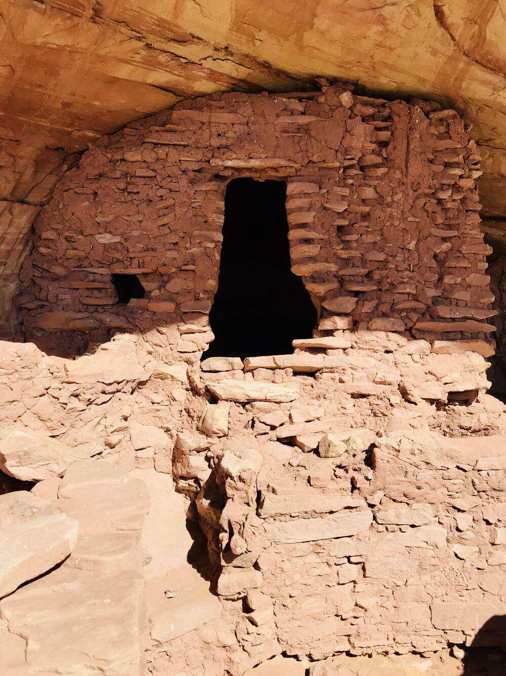
This saddens me as a conservative minded traveler.  There are many places in this overall area that need to be protected including many Native American ruins.


There is a road that crosses between the saddle between the two Ears and travels east and has been snow covered.  It snow a few times while I was in the area thwarting my desire to visit the Ears.  The Bears Ears saddle is only 6 miles from the road to Natural Bridges, but the road to the other side is many miles long.  When I first wanted drive Bears Ears the road was only open 2 of the 6 miles.


The snow was melting before I left Utah and I first drove up the east side, but the frost was coming out of the ground and the road was damp causing the mud to make driving deep and slippery.  I needed to turn around as I didn’t want to get stuck in the mountain.


Above is my 2nd and last attempt to get over Bears Ears looking over Arch Canyon to the west.  I was able to drive the road many more miles this time as the road was drying out.


Eventually, the snow in the woods and some on the road, as well as water and mud from melting snow bogged my 4x4 Tacoma with camper in 8 inch ruts.  What saved me was that at 8000 feet in the morning the mud was still frozen but thawing as I drove the road.


Some parts of the road with sun were much better than those section shaded.


I gave up from the east side a second time with ruts much deeper than those above.  I had all I could do to keep moving in the ruts and mud so I did not get pictures of the worse part.


I have Michelin LTX Mud and Snow tires with good tread but they are not off road tires.  Plus my camper is about 1000 lbs causing a lot of weight to sink in the mud.  Above my trees were full of mud and this makes traction difficult.

I did make it to 8500 ft this second time vs 7000 the first time.


After not making it over Bears Ears from the east I decided to return to Natural Bridges and attempt driving the southwest side to the saddle in the afternoon.  

I made the 6 miles as the road had dried enough but it left many ruts that were mostly dry and my truck had no problems with 4x4 engaged.


At the saddle the picture above is the west ear.


Then the picture of the east ear.


Above you will see a red pin drop.  This is how far I got trying to drive over Bears Ears from the east.  The blue dot is me parked at the saddle between the two Ears at 8513 ft elevation.

The line between the two points is 1.76 miles line of sight.  So since the road has a bend I figure that there was two miles of road that I could not get through on my quest to drive over Bears Ears before I left Utah.  

Oh well, there is next year as there is plenty more to see in this part of Utah.  Show and rain had come late this year and it was insufficient leaving the area in drought conditions.

Keep Bears Ears National Monument and Escalante National Monument (south central Utah) in your thoughts as both were drastically reduced in protective size from Trumps rollbacks of Obama’s efforts to conserve this area. 

Brent

macaloney@hotmail.com

Wednesday, March 28, 2018

The Two Canyonlands National Parks


Canyonlands National Park is very large and comprises of at least two different parks.  For the most of us who come to the Moab, Utah area want to see the two National Parks that are in the area.  They are Arches National Park and Canyonlands National Park.

Most that visit Canyonlands visit the northern part called Island In The Sky.  It’s a Mesa that most of us go to overlooks and gaze out at the canyons below.  Some take 4x4 tours or take their own SUV down the side of the Mesa and travel along the lower canyon rim.

The other half of Canyonlands is much further South and is called “Needles”.  One could argue there is a third Canyonlands in the far western portion where backcountry hikes requiring permits give those that go vistas of the Colorado River that meanders through the park.


Above is the northern portion (Island in the Sky) of the Canyonlands National Park.  Below are a couple photos of this section of the park that is most visited.  Until this year I have been to this part of the park a number of times.


The picture above is the road along the rim of Canyonlands that descends to a road that transgresses the “Island” on 3 sides.  It’s an adventure for some number who choose to take this back county trip camp on the canyon rim below.


Above the picture shows the canyons below the Island in the Sky Mesa from Grand View.  A close look you can see the road I mentioned above as it moves along under the Grand View and the rim of the canyon that looks like a three fingered hand.


The Island In The Sky is so high that vistas abound.


The less visited Needles area to the south is totally different, putting you into the canyons to the south of Grand View.  This is the first time I’ve visited this section and I want to say it’s a gem to see.  With the northern part of the park is mostly overlooks and although fantastic, the southern part of the park is more hands on.


Here you look up to canyon rims.


Get to view wonderful rock formations left behind from the great drainage of the Colorado River.  This southern area is noted for its vertical rock climbing too.


Above is how the ridge of needle rock formation occurred.


Here at a distance are the Needles.  Hikes in the southern part of Canyonlands are great opportunities to walk into geological history.


There is also history of the Native Americans and early exploration and settlers.


The road to Anticline to the East of Canyonlands is a Great Road to view both the north and South sections of Canyonlands.  

This BLM Land That this road is on offers views that can tie the distant views to the north to the far reaches of the south of the park.


It offered me views of wildlife.


Having to wait for free range cattle to get out of the road.


Camping with excellent 180 degree views.


Of course views of the Colorado River transgressing the Park in two.


From Anticline the view to the La Salle Mountains to the east provided me with an excellent photo of a cold snow covered mountain with some unique cloud formations.

I encourage visitors to Canyonlands to try to take the time to see it all.  My past visits to the Island in the Sky were memorable, but it’s a very large National Park with a lot more to see in the southern Needles section.

Brent

macaloney@hotmail.com

Saturday, March 24, 2018

Moki Dugway


(Google Pic)

In the map above to the left of the Valley of the Gods is Maki Dugway.  It’s best you look it up for details, but 3 miles of up hill on the face of the messa with 1.5 with road and wide spots to wait to pass and no guardrails.  

It sounded bad and put me off driving up it until I fixed my camper mount that broke.

Anyway, for me it was in part paying attention and no stopping for photos and why I’ve included one from Google.

It’s part of the Utah Scenic Byway.


Above is the Google Map of the road.  


(Google Pic)

I would drive it again and I feel I have been on worse roads like Mt Washington Toll Road in New Hampshire driving in zero visibility at times.  Out here there are many other Mountain roads that are not well maintained and more challenging.  

I’d drive it again

Brent

macaloney@hotmail.com

Thursday, March 22, 2018

Butler Wash Ruins


While exploring southeastern Utah, I drove on UT 95 many times, even staying at nearby Comb Wash.  I drove by the Butler Wash Ruins Overlook a few times before stopping to take a look at the cliff dwelling from across the canyon.


I seem to be captivated by how Native Americans came to live in these alcoves and then as mysteriously, depart the area. 


What I didn’t know when I visited this ruin was that Butler Wash had hidden secrets.


Such beautiful country with the snow covered mountains to the north.


The hidden secrets?

Here I am at yet another cliff dwelling in a wash.that is over 25 miles long, that isn’t marked for public viewing.  This one is only about a quarter of a mile from another simular unmarked ruin.


This one ruin has been visited by other respectful visitors, leaving chards of pottery they have found in the nearby dirt mound.


Others left chards in a grouping on the mound.


Across the canyon wall, and between the two ruins, is a Petroglyph panel, with both old and possibly new markings.

In my last post about Bears Ears and how the Trump Administration removed most of the protection from public land development that Obama had put on for the greater Bears Ears area.

There are marked ruins and Petroglyphs in most washes/canyons in southeastern Utah and it would be a shame to open up such areas for licensed development by our Federal Government.

Brent

macaloney@hotmail.com

Tuesday, March 20, 2018

Broken Camper Mount - Causes Emergency Repairs


I keep an eye on how the camper sits on the truck.  Some time ago, I had done some adjusting on the trip when I saw the gap on the passenger front bed was larger than the drivers side.

This time I figured all I needed to do was retighten the turnbuckles.

To my surprise the front passengers turnbuckle was not connected.  Note that I have to removed one of my lower bed boxes to check and slide a small wooden window open.

I can only guess that one of the nasty bumps that I encounter on dirt roads looking for disbursed camping, or a street speed bump I may have not seen fast enough to slow to a crawl must have snapped the carriage bolt.


I reached in and came out with the turnbuckle.  The bolt that comes through the camper was missing the loop that screws on


I was able to hammer and pry the carriage bolt out from the camper.  Note the aluminum backer plate to spread the stress of the bolt when tightening.


The part that was missing was the cast threaded loop.  I can only get my hand into the area between the bottom of the camper and the truckbed so far and could not feel it.


I changed my exploring/travel plans for the day and drove to Blanding, UT.  I big enough town to have a well stocked hardware store.


(Google Photo)

Since I could not find the part that broke off and was floating around under my camper, and I couldn’t find the exact replacement part, or some other closed loop that I could attach with a 3/8” threaded bolt, I decided that it would be better to used an eye-bolt like the one above to get by.

I made sure to mount the eye with slight gap away from the turnbuckle as not to stress the bolt eye to open.

While at the hardware store I also got some other 3/8” parts in case I find the original part to put the camper back to original and have some spare parts, as I still have a lot of back road roaming to do in southern Utah.

As a prologue, you can see from the picture above that I did eventually find the missing part that goes with the carriage bolt floating around after some driving.  So, I will keep my spare parts for future trips.

The camper weighs about 1000 lbs and is held down with 4 - 3/8” bolts.  Not running with 4 is possible but with bumpy roads that cause the camper to stress and try to shift should not be left unfixed, even temporarily.  

I did resume my travels and my temporary fix worked fine on the 3 mile 10% grade incline with switchbacks, and other back roads of Utah.

Brent

macaloney@hotmail.com

Monday, March 19, 2018

Valley Of The Gods


(Photo from Google)

The Valley of the Gods in southeastern Utah, North of Mexican Hat, UT and south of Bluff, UT, and is one of my favorite places to camp and tour in this area.

This BLM primative dirt road was in good shape this year and I camped one night on east end and another day I drove the length of the road.


Being north of Monument Valley to the south on Navajo Nation Land, you are rewarded by similar structures along the road.


My Prius has made this trip and would have been able to do it this year as well, but with the low clearance Prius, much more care must be taken for random large rocks in road and bottoming out in dips.

Look at the recently graded road below.


Coming in from the east you cross a wash.  The wash water flow this time was minimal.  In fact it was 2” deep when I crossed with my Prius 2 years ago.  Don’t cross with a car if you haven walked the wash to prove it is flowing less than 4”.

Of course, with my truck/camper I have little worry or thought on height issues, but I do have to look out for one thing that can give me a bad day.


That one thing is going too fast over bumps.  It Telly doesn’t have to be too fast or bumps bigger than speed bumps. I have airbags to absorb the majority of the bounce shock, but it doesn’t absorb it all.

Somewhere since Page, AZ I must have gone over a bump that caused me problems.  I was going to climb a big steep switchback grade but stopped as I had just checked my FWC camper’s 4 turnbuckles and found one mounting bolt broken.

I opted to not take the climb with only 3 tiedown’s working and went to find parts for a repair.  I will document what broke and the repair in a separate post.  


Above is only a sample of the Valley of the Gods Road views and this is what you see when you go to bed and wake in the morning.

You can see why it is a great place to visit.

Brent

macaloney@hotmail.com