Thursday, April 3, 2014

Day 77 - 4/3/14 Desert Museum

At my stop at Mc Donald's this am Ronald McDonald stopped in to say hi to folks.


He was actually a good looking Ronald and played the crowd well.

=======================
Desert Musrum:

The Arazona-Sonora Desert Museum is located next to the Saguaro National Park West.  It is immediately before the trailhead I parked at when I climbed Wasson Peak the other day.

I passed over this as a point of interest before now but their brochure caught my interest and it went up on my list.


It says "Top 10 Museum in the World".  The website didn't sell itself either do I took a chance and decided to go. The cost was $19.00 got an adult.  The senior discount here doesn't start until your 65.


When I arrived at 10:00 there was a good crowd already there.  From what I read it takes a minimum of two hours to tour the museum.

There are two circle routes in the park connected at one spot with smaller loops or spurs off theses loops.  The loop closest to the entrance is a concrete walkway that connects museum and display buildings. The outer loop is a hardened dirt path through the Sonoran Desert environment.


This is a view to Wasson Peak across the road.


The museum is a zoo with 230 animals, botanical gardens with 1200 native plants, museum, gallery, and aquarium.

I liked this flower for its mix of orange and yellow. 


There was a netted humming bird environment. It's hard to catch a humming bird in flight, but I caught this one, although a bit blurry.


In a separate netted rnvironment this bird dressed in blue posed for me.


This bird dressed in red didn't want the blue one to out do him, so he also posed for my picture. 


This diagram shows the desert environment change as elevation changes and as does what grows at what elevation.


There is plenty of cactus here at the museum. I told Denise tonight that the museum would have been a good place to go first when arriving in the area, as you learn about what you will see when hiking the mountains.

Yesterday's hike on Finger Rock Trail went through all the environments shown on the chart above.


I liked this overlook / rest stop with the interesting supports for the canvas.


Here is one of the cat animals in the zoo,


They have a cave display and next to it is a mineral display.  Here is an interesting piece of copper.


Some more minerals.


At 2:00 pm there was a live raptor demonstration that drew nearly everyone in the park.

The post in front is a metal statue.


Here is one of the many raptors showing off in flight.


The bird in the hand.


The raptor was the last stop for me on my tour of the Desert Museum that took me 5 hours to visit everything.

There are many displays around the park and one I stopped at was manned by Volunteer Cathy.  I have previously written about the number of volunteers I have met on the trip that support parks and museums.  

Cathy is a 60 something soft spoken woman with blue eyes and pleasant smile.  I stopped at her display as she was a bit off the path getting shade from the sun and wasn't catching many people.  She was displaying fossils.  I had her take me through her script and then started a conversation with her about her volunteer efforts.  

She volunteers at the museum once a week on Thursdays.  You can tell Thursday is her day and she enjoys doing it.  I asked her if she gets to pick what she does or gets to do other volunteer jobs and she said yes.  She said she can sign up but management has priorities for what must be filled before other jobs.

At once a week, I was thinking that wouldn't be too bad to volunteer, as it wouldn't take up a lot of your time.  Most volunteers are, or appear to be retired but not all.


When I was leaving I saw this sign advertising that the museum is looking for volunteers.  I thought this was good marketing.  Then just down the walkway there are brochures to take about volunteering.  This place looks like a fun place to work.  

I guess the Colossal Cave would be fun too. 


Remember that my blog does not cover everything I learn about, everything I do, or ieverything available to see.  This museum has a lot more to see and do that what I covered, and is well worth the $19.00 I paid to get in.  As with all my blogs if you have questions let me know.


Wednesday, April 2, 2014

Day 76 - 4/2/14 Finger Rock Canyon Trail Hike

Today was a hiking day.  The cold front came through yesterday with high winds, so today it was only going to make it to 70 in Tucson.  In the mountains it was near 50 when I started the hike and in the 60's on the way back.  On the way up you hike in the shade so it was very cool.

This is the mountain range north of Tucson where Finger Rock Canyon Trail is, kind of in the center of the picture.


I selected this trail as it it was an aggressive hike that will push me, and push me it did.


I arrived at the trailhead at 8:00.  This is a long hike so if your planning to go to the top you need to start early.

There were a half a dozen cars in the parking lot that holds about 30 cars.  This parking lot is also used for a smaller trail too.  

As with other trailheads I have been to, they are in residential areas and there is no on street parking.  I would recommend that if you were arriving on a weekend you should plan on arriving by 7:00.

This is the street and the trailhead parking is on the corner at the curve of the road. View is looking south to Tucson.


The trail looks small on the map.  Even short.  It is far from that.  Listed on AllTrails as 8 miles out and back with an elevation gain of 5280.  This is just under the Grand Canyon elevation from the ranch up the trail to the south rim at the Lodge.  If you can hike this you are possibly ready for the Grand Canyon.


Thos climb is not for the novice hiker.  I met 3 woman hiking down then 2 other woman hiking down that had hiked out 2 hours and turned around having not gotten even half way to the top.

The hike starts off with a slight incline for some distance before it turns to the canyon's right (east) side and gaining elevation quickly.


I have worked up to his hike and I felt I was ready and I was.  The hike was in the shade for a good amount of time going up.  This helps with not overheating on the way up, even though I still sweat with just a tee shirt on in the 50's.  When I stopped to talk to the two woman one was cold, not having planned for cool weather. I got chilled as I had sweat thrill ugh the back of my tee shirt.


Here is Finger Rock in the center.  You can see this all the way up rhe canyon until you get to the side view blocked by the formation on the right.


Still getting higher in the canyon. This is about 2 hours of hiking into the canyon.

In the distance you can see the mountain range where I hiked Wasson Peak.


Here I am approaching the point where I will not be able to see Finger Rock on the way up to the saddle.


Below is the saddle in the center that connects both sides of the canyon.  I am now 3 hours into this hike.  I hike another 1/2 hour to the top.


Rock formations on the side of the saddle.


View back to the city.  I hiked 3.5 hours and there is a number of spots where you have to use your hands to get over rocks.

I hadn't seen anyone since the woman that turned around.  That was 1.5 hours ago and much of the time there was no cell service.  Thinking toy self that they don't recommend you hike by myself.  Doesn't give me many options if I want to hike so I take some risks.


I was out here by myself and it was now 12:30 and I know that it will take me about the same amount of time to get down due to the rough trail conditions. I am at the top of the saddle and there is about .5 mile trip to get to get to finger rock.  This is about an hour of hiking one way and this would get me back late and since the saddle is nearly the same vertical elevation I met my goal for a strenuous hike and I turned around.  It was another 2.5 hours before I saw another person.  That was 4 hours being all alone.

With the afternoon sun now shining on the on the trail, I did see 2 snakes that were the same type within a short distance.  They were Wandering Garder Snakes.  Non venomous snakes.  They scurried off as I scared them stepping over the rock going down hill.  I scared them and they startled me, as I was looking out for rattle snakes.

(Internet photo)


Yes more flowers.


I liked this flower as it had two distinct colors.


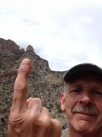
Here I am giving Finger Rock my finger.

You can see a cut on my finger thanks to a cactus that jumped out and stabbed my finger.  On the other hand I was stabbed by a different type of cactus in the knuckle.


The other day when I hiked Wasson Peak I wore my 6" high hiking boots.  This was a 7 mile hike with much less elevation and when I got back both inside heals were hurting.  I have not had problems with my trail shoes that are a lower cut so I wore them today.  

They wore well but near the end the balls of my feet on both sides were sore from getting some sand grains in the shoes.

I need to get out my lightly used stiff sided hikers to tryout when I get home.  

Tonight as I write this I have mussle cramps in both thighs.  Ouch!  This is a first on this trip and I think it was due to the extensive number of rocks that I needed to climb over today on the trail. Having long legs I lifted my legs and pushed off and up and over the rock thus working the thighs on this hike.

As noted before this hike is not for the novice.  My legs held out well and I did not suffer significant fatigue in my legs. They were getting tired but they were not worn out and could have gone further to the Finger Rock.

I had my 2 liter camel pack full with water, and I carry a spare bottle of water. 
My rule is that once my 2 liters are gone I'm headed down and I have at least one bottle to get me out hydrated at some level.  I used all my 2 leters on this hike and had my bottle left, but this hike tells me that you should hike with at least 4 liters and I saw one post saying 6 wasn't enough.  The temperature could be the difference.  If you are hiking plan for plenty of water.  I am thinking I should have a second 2 liter camel pack for these long hikes rather than supplement with bottles.

Check out AllTrails website and comments others have posted on this hike.

http://alltrails.com/trail/us/arizona/finger-rock-canyon-trail 

Tuesday, April 1, 2014

Day 75 - 4/1/14 Mission San Xavier del Bac / ASARCO Mine

There are many things to do and see here in Tucson.  This morning I headed out to Mission San Xavier de Bac. This is one of the missions as part of the New Spain expansion of the new world and only 9 miles south of Tucson.


The expansion of Christianity resulted in missions being built generally along rivers where Indian settlements existed.  They were spaced at a one days ride on a horse apart.  

This part of the US was under Spanish control, then Mexico, and finally the United Stated with the acquisition of this land as part of the Gadsden Purchase.

From the Mexican's point of view I would bet they would see our acquisition no different than Russian's acquisition of Crimea.  Yes, the US paid Mexico for the land but the US basically took it so they could get the southern route of the Trans contentinal railroad.

It's interesting that we in the US have righteous attitudes about things when we have done the same thing in the past.  We also did the same with Canada.  Remember "54/40 or fight".

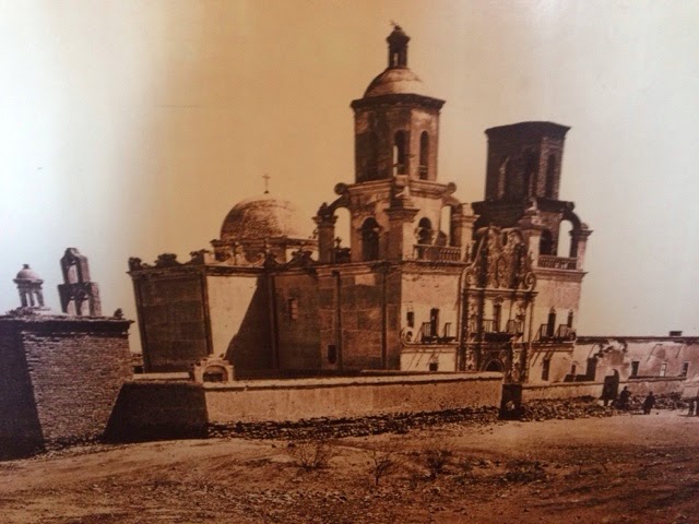
Moving off of politics and back to the Mission,  the building is impressive.  Although not the original Mission building it is an excellent example of architecture that is a mix of Mission style as well as Moorish.  The reason for this is that Spain was occupied by Moors from Africa for a number of years.  It has 2 towers generally used for calling to prayer.  It also has a dome in the center that took a square frame and transformed to a oxagional to a dome.

Here is a miniture mock up of the complex.  See the dome on the center of the church.


I like architecture and the Mission can be seen for a few miles from the highway with it's white color that stands out as well as it is open and not surrounded by other buildings.


Then there are the architectural appointments.  That are so many and also wonderful.

This side has been restored and why it looks so good.


This side had a top on it as it took a number of years to build and they ran out of money on the other side.


Note the details above the windows.


The center is very ornate and covered with symbolism on every part of it.


New Spain abandoned the missions and this one was left open to the wind any anyone that came by to use it for shelter.

The local Indians kept artifacts hidden away in their nearby land and turned it back over to the church when they returned.  (This is a story all by itself.) 


The interior was blackened inside from squatters that had set fires inside to keep warm.  The paintings on the walls needed restoration cleaning to make them viewable again from the spot from the fires.  The good news is that some people cared and still care and  are raising money to restore the other side.

The mission, along with others coming up from Mexico from the south were under the direction of Father Kino depicted in this statue.


Painting on wall depicting the last supper.


In this rendition the artist painted the devil  in the shadows on the right side.


The following two photos are of the wings on either side of the main alter.

The statues in each are presentation statues that are taken out for religious parades.  They each have multiple sets of clothing for the occasion.


Check out the number of colors used in the design.


The main alter as well as the two wings are full of symbolism.


The inside dome. Square to oxagional to dome.


The missions were supplied with sculptures from a single so called mission sculpture facility near musician city.  Like this angel below they were sent out with no color or clothing.  The clothing would be added at the mission and then colored.  They used real clothing and would soak it in plaster (gesso) and then formed to the style and hardened.  Then it would be painted.


This last statue is of an Indian woman Kateri Tekakwitha that was given Sainthood in 2012.  Her story is interesting and long so please see http://en.m.wikipedia.org/wiki/Kateri_Tekakwitha for further information.


ASARCO Mine:

A few exits down I19 towards the Titan Missle Silo I went to the other day is the ASARCO open pit copper mine.  Yes a strip mine.


They give tours and I wanted to see what  they do there.

Let's put the size of this mine in perspective.  The mine is 31 square miles.  To give you a reference Westminster, MA where I live is 37 square miles.  This is a large complex that when you drive down the interstate you drive mile after mile of removed debris from the mine pit.

The tour starts in their gift shop/visitor center with displays and short informational movie.

Here is an aerial view of their open pit mine.


We boarded a bus and drove a few miles to the processing plant.


To make this short, they have to remove the rock on top of the copper ore and this is done with drilling, blasting, and hauled away to make hills/mountains.


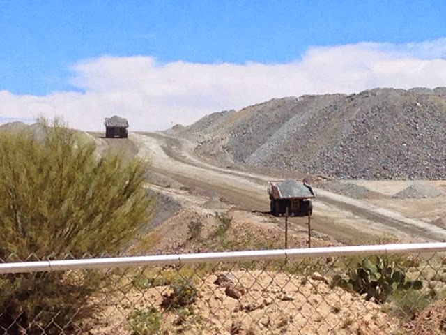
These trucks as well as other equipment is as large as it gets.


The ore, once it is found underneath, is taken to be crushed in a series of processes to the point it is pulverized dust/granular.


Then through a partial chemical and physical process the copper is extracted from the ore.


This is where the copper is separated from the process.


The result is 28% copper ore that is sent to smelting.

They recover Sulfuric acid & some small amounts of silver, gold, etc

The silt / slurry left over is put in silt beds.  Below behind this bim is the processed waste either the material removed prior to the ore or the silt.


The copper after smelting is only 90% pure so it is processed again through an electrolysis process to 99.9% in Texas.


 d